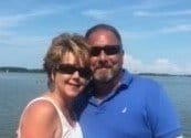
Bio-One of Harrisburg services all types of trauma, distressed property, and biohazard scenes in communities throughout Pottsville Area. We partner with local authorities, communities, emergency services personnel, victim services groups, hoarding task forces, apartment complexes, insurance companies and others to provide the most efficient and superior service possible.
We are your Pottsville crime scene cleaners dedicated to assisting law enforcement, public service agencies and property owners/managers in restoring property that has been contaminated as a result of crime, disaster or misuse.
Pottsville is a city in, and the county seat of, Schuylkill County, Pennsylvania, United States. The population was 14,324 at the 2010 census, and is the principal city of the Pottsville, PA Micropolitan Statistical Area. The city lies along the west bank of the Schuylkill River, 52 miles (84 km) south of Wilkes Barre. It is located in Pennsylvania's Coal Region.
Geography
Pottsville is located at 40°41′06″N 76°12′10″W (40.685058, -76.202747). According to the United States Census Bureau, the city has a total area of 4.20 square miles (10.9 km²).It is all land; none of the area is covered in water. Although there are no lakes within the city there are several water courses which flow through the city. The Schuylkill River flows through the extreme southern part of the city near Mount Carbon. The West Branch of the Schuylkill River makes up most of the western border of the city. Within the city itself the West Branch of Norwegian Creek flows through the Fishbach section of the city and the East Branch of Norwegian Creek flows through the Jalappa section of the city. Joining together near Progress Avenue and Terry Reiley Way they form Norwegian Creek which flows underground through the heart of the city. The creek empties into the Schuylkill River at Mauch Chunk Street.
Demographics
As of the census of 2000, there were 15,549 people, 6,399 households, and 3,877 families residing in the city. The population density was 3,697.4 people per square mile (1,426.0/km²). There were 7,343 housing units at an average density of 1,746.1 per square mile (673.4/km²). The racial makeup of the city was 95.73% White, 2.26% African American, 0.12% Native American, 0.51% Asian, 0.01% Pacific Islander, 0.53% from other races, and 0.84% from two or more races. Hispanic or Latino of any race were 1.22% of the population.
There are 6,399 households, out of which 27.3% have children under the age of 18 living with them, 41.7% were married couples living together, 13.9% had a female householder with no husband present, and 39.4% were non-families. 34.9% of all households were made up of individuals and 17.2% had someone living alone who was 65 years of age or older. The average household size was 2.29 and the average family size was 2.97.